|
|
 |

|
Dr. Regener LandMap
Vivo
|
(Version 10) |
|
|
Vivo Cache - own maps even witout own data !
GPS enabled and witout extra charge.
|
|

|
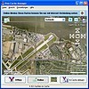
The Vivo technology is the key revolution of this version
Aereal and satellite fotos and roadmaps loaded
from the web, stored local and used directly and rapidly without internet
this means. own maps without own data: no scann of paper maps,
no order of official maps
draw directly areas on the aereal foto and view instantly the area size(hektars,
acres)
analyse GPS-tours on the background of aereal fotos and road maps
print true to scale without background
|
|
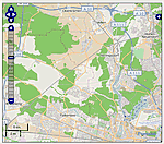
Import from OpenStreetMap - the free world road map
|
|
|
Import ready road maps
Edit, format in "LandMap Vivo", measure areas
Worldwide database, GPS enabled
The material is absolutely free of any licence fee
|
|
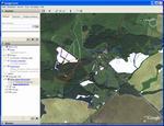
Geo-Maps from Google-Earth!
|
|
|
Create GPS-enabled vector maps in "Google Earth", copy/paste them to "LandMap Vivo"
and make all what you cannot do in "Google Earth"
- Measure areas
- Insert symbols and text labels
- Print resulting vector maps true to scale without satellite background
|
| and ... |
|
Import |
-
Geodata from GPX, GPS loggers and "GPS for Google Earth"
|
|
Draw |
-
Manual vectorisation of maps in an easy way
|
|
Export |
- as pixel graphic (TIFF, Bitmap, PNG, JPEG) for use in external programs
|
|